
I have had a previous flirtation with high points. On the list of "most interesting" wikipedia articles at a lofty 115 is Jerimoth Hill, for many years the least accessible state high point. That's right. More people had been to the top of Mt. McKinley than to Rhode Island's highest point. Therefore, this whole mess has been stewing on the back burner for about a year now, and as everyone knows, chili gets better with time.
Let's grab a spoon and dig in.
My hypothesis:
I think it's possible to hang-glide from the highest point of Alaska to the lowest point (the ocean). I swear it has to be possible, right? I mean, McKinley/Denali is right there. And doing a little guesswork from the actually incredible lift generated by modern gliders, I would say there might be other states that have as easy a time. I know Mauna Kea is a shield volcano and not super steep, but it's really tall. Maybe you can glide the length of Hawaii. And what about Washington? Mount Rainier is really close to the ocean. I think the feasibility of a state-wide hang-glide is highest in Alaska, then Hawaii, then Washington. Last is Florida, as it shall always be. So: can you hang glide off Denali?
My findings:
Huh. Apparently so. I don't know if they made it from the summit to the water (I assume not--landing in water is a really risky proposition when you're wrapped in climbing gear) but it's feasible. Terrific!
My personal hell:
You know the drill. There's no reason to not get scientific on this. And it didn't take me four days to find Jim Hale. So what did I spend my time on?
First, I struggled to make iWork do what I wanted. Since Apple assumes I am an idiot and need my hand held, I made my spreadsheet full of boring numbers in Google Sheets. Seriously, click that. Then, I turned that spreadsheet into confusing lines and dots. The lines and dots are more confusing than necessary because no matter what I tried, I could not get altitude to take the y value, so the further right something gets, the higher it is. Awful.

The confusing lines and dots took three days to finally make even roughly workable (during which time I tweeted angrily at Apple and posted on a Google forum at 1am). Because I love you and I want you to understand this stuff I've found, I'm prepared to write instead of graph. I need you to know that for the lowest spot, I fudged as best I could. Many are coastlines. I chose the closest and guessed with tidal rivers. You should know that one source made everything possible. You should further know that iWork is for dirty casuals. Sources for information: wikiped (mostly). I'm not hitting every state. You can probably read Wikipedia on your own. Good luck.
The States:
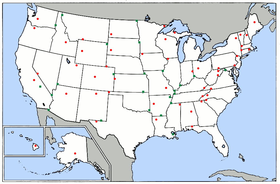 |
| Basically all the work done for me already, so I did it all again. |
Our magic number--the feasibility index for a human being to possibly glide from high point to low point in an unpowered craft is 60m horizontal for every vertical meter. That's insane. That should not be possible. But in a modern sailplane with an almost impossibly wide wingspan, you can do that. So: Magic number 60m/m.
Louisiana: Least hang-glideable state
Highest: Driskill Mountain. Lowest: New Orleans. There are shorter states, and there are longer glides, but there are no short states with their high points so far from their low point. And New Orleans being 2.4 meters below sea level didn't even make the slightest blip. You would need to travel more than two and a half kilometers for every meter you drop, and that's so laughably impossible that I'm surprised we haven't just cut Louisiana out of the Union for being such an embarrassment.
Michigan: Able to admit when they're wrong
Highest: Mount Arvon. Lowest: Lake Erie. This one is another impossibly long glide. How are you going to go a kilometer and a half with a meter drop? You won't. Michigan is notable because for years they hailed Mount Curwood as the tallest point in the state, though who can blame them: Arvon is a record-shattering one foot taller.
Kansas: Not the flattest
Highest: Mount Sunflower. Lowest: The Verdigris river at the Oklahoma border. Kansas is not the flattest state and now it has the shocking distinction of also not being the stupidest idea a hang glider ever had. If you managed a measly two-thirds kilometer for every meter you lost in altitude, you could handily glide Kansas.
Oklahoma: The one Free man
Highest: Black Mesa. Lowest: The Little river at the Arkansas border. Two thirds km per vertical m. I know what you're thinking. "But Robby, Black Mesa is in New Mexico!" Well, it wasn't a secretive research base for nothing. They had you fooled all along.
Kentucky: *Deliverance whistle*
Highest: Black Mountain. Lowest: Mississippi river at Missouri/Tennessee border. Two thirds km per vertical m. The MO/TN/KY border comes at a huge, sweeping bend of the river known as Kentucky Bend. Because the early states were greedy and assumed anything west of them would forever be theirs (how stupid do you think we are, New York?) the border between Kentucky and Tennessee was agreed upon as flat. That meant that accidentally, a tiny portion of land is cut off by the river as it sweeps back and forth along the line. There's an exclave of Kentucky there. Its population? Seventeen. I guess they're not proud of their lowest point.
Missouri: My home state
Highest: Tom Sauk Mountain. Lowest: The Saint Francis river at the Arkansas border. About a half km per vertical m. Two things are of note here. First, I expected the Mississippi to be the lowest point in Missouri, but apparently not? I don't know how that works, geographically. I guess the Mississippi drains into the St. Francis. Second, apparently all the jokes Katy and I made as kids were wrong. Tom Sauk is a true mountain, caused by igneous uplift. It's not as famous as some other igneous intrusions.
Tennessee: Too proud of their mountains
Highest: Clingmans Dome. Lowest: Mississippi river at Mississippi border. One third km per vertical m. The highest point in Tennessee was named by the same man who named the highest point in North Carolina. It's kind of a joke among 1800s Appalacian geographers, which is possibly the most specific in-joke in history. A Civil War general and a professor from North Carolina had a years-long fight over which was the higher mountain in the region: Black dome in NC or Smoky dome in TN. They spent the entire 1850s fighting about it until Guyot nailed the height definitively. He pushed for Black to be Mt. Mitchell and for Smoky to be Clingmans dome. Which one's higher? Mitchell. By 12 meters.
Additionally: There's a single sentence without context or explanation on Clingman's wiki page.
In the early morning hours of June 12, 1946, a Boeing B-29 Superfortress crashed near the summit of Clingmans Dome, killing all twelve aboard.Massachusetts: I found a lower point
Highest: Mount Greylock. Lowest: Not actually the Atlantic. There are tunnels under Boston Harbor that are a whopping 30.5m lower, not that it matters. (I had to add the lowest elevation to wikipedia. I'm proud.)
Utah: The high-pointer's equivalent of a blood oath
Highest: Kings Peak. Lowest: Beaver Dam wash at Arizona border. We've taken a huge jump in feasibility, which is to say Utah is less impossible to hang glide than Tennessee. Still impossible. 169m horizontal for 1m vertical. The reason Utah is notable is the extreme commitment you need to actually reach the peak. The shortest route is a 32 mile hike, mostly over boulder fields. It's the hardest high point to reach without climbing equipment.
New Jersey: It just wasn't good enough
Highest: High Point. Lowest: The Atlantic. 152m/m. The appropriately named High Point just wasn't tall enough for you, Jersey. You had to go and build--and I am not joking--a monument one eighth the total height of your state and stick it on top. Depressing.
Connecticut: My personal contribution
Highest: ~Mount Frissell. Lowest: Long Island Sound in the Atlantic. 152m/m. How sad is this? The highest point isn't even the highest peak in Connecticut. They literally have their high point marker on the side of a mountain in Massachusetts. There were no gps coordinates for the high point. I literally had to find them online and add them to wikipedia.
Nevada: Even when you have a good idea
Highest: Boundary Peak. Lowest: Colorado river at California border. 136m/m. So, I had an idea. Follow me here: Where is the lowest point in the United States? You've always heard that it's Death Valley, but what if there's a mine that's lower? Now, the list of the lowest 10 mines are all foreign (and mostly South African) and there's no equivalent list dedicated to the United States. The closest thing I could find was the Combination Shaft in the Comstock Lode. It's a tremendous 990m deep! But Nevada is stupid and the lowest point in the mine is still 736m above the Colorado river. Dig deeper, mates.
Colorado: Highest low point
Highest: Mount Elbert. Lowest: Arikaree river at Kansas border. 131m/m. The lowest point is just a gully, but it's important because it's higher than the highest point of 18 states. Even you, New Jersey. Get over yourself.
New Hampshire: A weird distinction
Highest: Mount Washington. Lowest: Atlantic Ocean. 79m/m. We're so close. Anyway, Mount Washington held the global wind speed record from 1934 to 1996, when those cheaters in Australia took the record with a cyclone, which is 100% not fair. Anyway, 372km/h isn't anything to shake a stick at.
The Threshold
| Flight Medium | Scenario | Glide Ratio |
|---|---|---|
| Modern Sailplane | Gliding (depending on wingspan) | 40-60m/m |
| Hang Glider | 15m/m | |
| Gimli Glider | Boeing 767-200 out of fuel | 12m/m |
| Paraglider | High performance model | 11m/m |
| Helicopter | Autorotation | 4m/m |
| Powered Parachute | Rectangular/Elliptical | 3.6-5.6m/m |
| Space Shuttle | Approach | 4.5m/m |
| Wingsuit | Gliding | 2.5m/m |
| Northern Flying Squirrel | Gliding | 1.98m/m |
| Space Shuttle | Hypersonic | 1m/m |
| Apollo CSM | Reentry | 0.368m/m |
Our magic number is 60m/m, according to Wikipedia, and we're about to cross it in a very unspectacular fashion. Are you ready for the states that are mathematically possible to glide across? We're not skipping states now, so hold on to your bonnet.

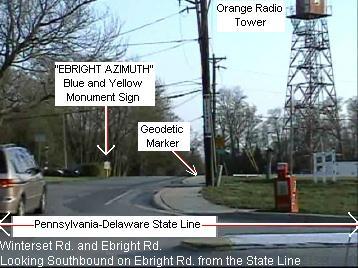
Delaware: I am aware of how crazy I sound
Highest: ~ the Ebright Azimuth. Lowest: The Atlantic Ocean. 59.95171196m/m. That's right. If you had an utterly enormous sailplane and the right winds (and someone bulldozed you a path), you could make it to the sea. The Ebright Azimuth is as exciting as it sounds, and it deserves the ~ just as much as you can imagine. The Azimuth is supposedly the highest point of Delaware, but the bureaucrats who had the sign installed put it on the wrong side of the street. The highest point is, fittingly, in a trailer park. I don't know how they missed it: it's actually a wider margin than Michigan's 0.3m error. Idiots.
Oregon: Blood from your pores
Highest: Mount Hood. Lowest: The Pacific Ocean. 57m/m. Mount Hood's height varies by as much as three meters, which is unsurprising when you realize it's actually a terrifying death volcano with the possibility of wiping away most of Portland with lahars (which, depending on if you like food trucks and no-cruelty vegan sandals, is either tragedy or boon). Anyway, the 1850 expeditions gave an (extremely) inaccurate height estimate and reported that, and I do not make this up:
"pores oozed blood, eyes bled, and blood rushed from their ears."Minnesota: I was so close
Highest: Eagle Mountain. Lowest: Lake Superior. 46m/m. When Delight and I visited the Boundary Waters Canoe Area Wilderness, which I spell out because it's fun to say the initals BWCAW, we drove within ten miles of Eagle mountain. From there, we drove down to Grand Marais. I can confirm that the road does tilt considerably. This one I might be tempted to believe is possible, if the conditions were perfect.
Alaska: Less glideable than I imagined
Highest: Mount McKinley Denali. Lowest: Knik Arm of Cook Inlet in the Gulf of Alaska. 35m/m. On a map, Denali always looked so close to Anchorage. Considering that in the same distance you could go to space and back and that you would take two hours to drive the same at highway speed, Denali is not close to Anchorage. Hang gliding that distance would be a feat of endurance, but the truly incredible thing is that it's theoretically possible.
California: The continental US extremophile
Highest (of the lower 48): Mount Whitney. Lowest (of the 50 states): Badwater Basin in Death Valley. Since apparently the land is basically on its side, the ground goes up four km in a paltry 150km, which means an impressive, if not mind-blowing, 34m/m. Just a side note for lowest points: they seem to all be hellscapes. If they're not the hottest point on their continent, they're the saltiest, driest, and most wind-swept. Most of them contain water that would cause even me to float (which is saying something; my rescue float is agonizingly exhausting because I have to paddle to breathe). Strangely, these hypersaline lakes are not the most salty water on the planet. That honor goes to a tiny lake in Antarctica which, and I am not joking, stays liquid at -30 Celsius. The max depth is a foot and I don't think I'll be swimming in Don Juan Pond any time soon.
Vermont: Their highest point looks like a face
Highest: Mount Mansfield. Lowest: Lake Champlain. 26m/m. I have nothing to say about Vermont. I guess they think their highest mountain looks like an elongated human face.
Washington: Yup
Highest: Mount Rainier. Lowest: Puget Sound in the Pacific. I just have to say that Puget Sound is a foot magnet. I was actually right about the hang gliding (18m/m) even though they don't allow hang gliding in the park. And I hate to douse your enthusiasm by repeating myself, but do you remember what I said about lahars? Well, Mount Rainier is the most dangerous volcano in the United States, and one of the most dangerous in the world. Millions of people live in its shadow, and I'm here wondering if you could hang glide off it.
Hawaii: The only reason this whole list isn't insane
Highest: Mauna Kea. Lowest: Pacific Ocean. In order to successfully glide from the top of the volcano to the ocean, you would need to glide seven meters for every meter you drop. Not only is that possible in a sailplane, you could do it in a conventional hang glider or even, shockingly, a paraglider. This enthusiast's website mentions (hearsay) that people used to glide from Mauna Kea all the way to towns on the shore (Kona). I guess that means . . . I was right. Nobody expected that. You can't do it anymore, though, as the University of Hawaii and the state have banned use of the airspace.
There are a few factors that make my proposition even more likely. First is wind patterns. As wind travels up a mountain, it creates an enormous updraft that can lift flyers to incredible heights. That's called a "wave." Especially around the twin peaks on the big island of Oahu, there are some of the best waves in the world. With practice, even I could hang glide from Hawaii's highest point to her lowest point.
Luckily, we're not done with the list.
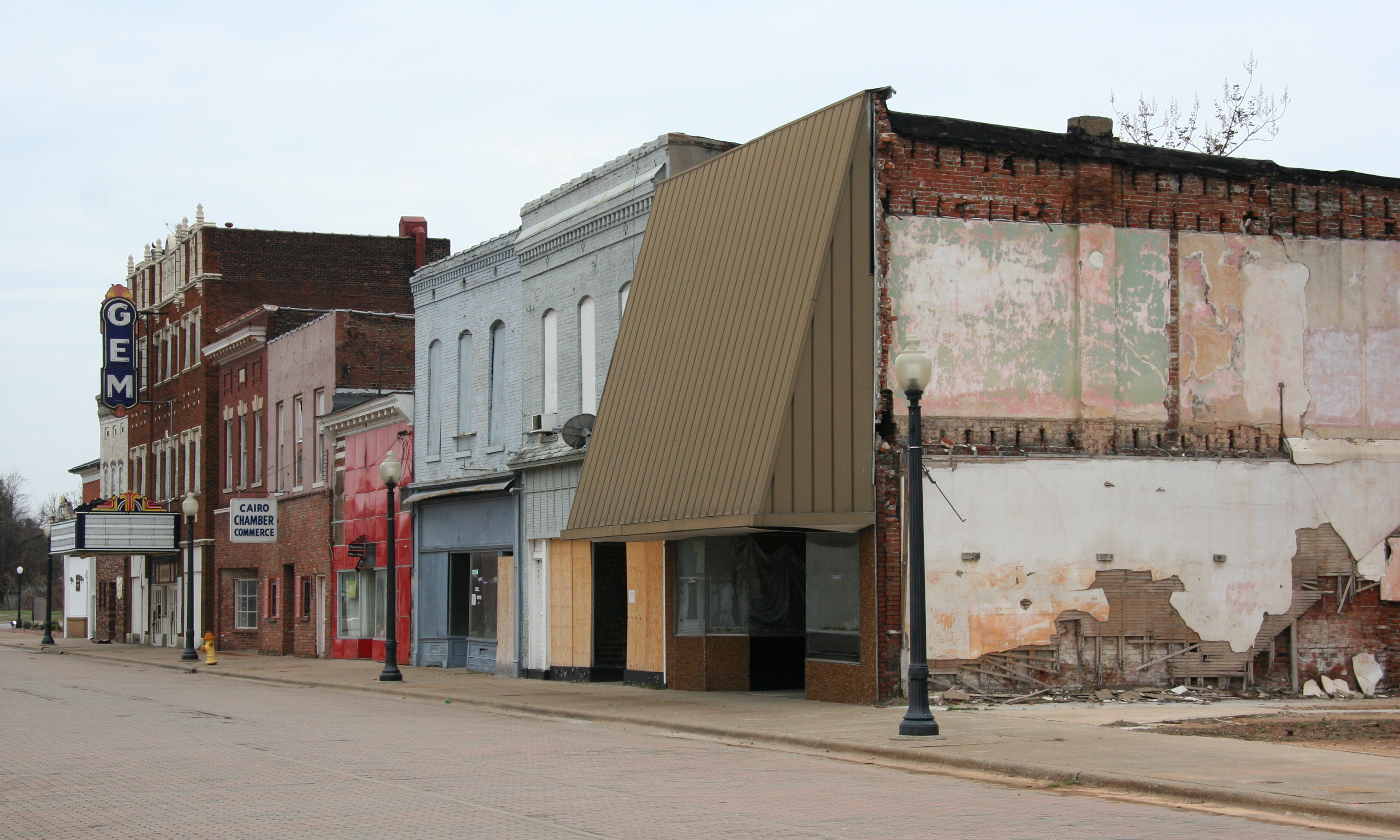
Illinois: Insecure about her height
Highest: Charles Mound (that's right. Mound.) Lowest: Confluence of Mississippi and Ohio rivers. That's Cairo, Illinois, and possibly the saddest story any town has ever told. I took pictures there a few times. Two words: urban decay.
Finally,
Washington, DC: A highly illegal proposition
Highest: Fort Reno. Lowest: the Potomac river at the Maryland border. While Fort Reno is x2 not glideable (it's so low and it's inside a military base), there is a much taller surface to start your glide from. It has the added bonus of being oh so close to the Potomac and being the tallest surface in the district. It's so glideable. You could make it in a wingsuit, because it's just 2.2 meters per meter. So, even though I'm not exactly sure if its even legal for me to promote this, I will give $1000 cold hard cash to the first person to videotape themselves wingsuiting off the Washington Monument into the Potomac river.

Some additional facts: at the top of Denali, I have a gravitational potential energy of 5.4 megajoules or 1.5 kilowatt-hours. That means you could pay an energy company 14 cents to throw me from the top of the mountain, if they could collect the energy at the bottom. That means I would land with the same force as 1.3 kg of TNT exploding. That means basically nothing.
The highest point attainable by an ocean-going vessel is in Whitehorse, Alaska. It's a point higher than 14 entire states.
The distance between Denali and Death Valley is 1/9 the circumference of earth. It's basically the same distance between New York and Los Angeles. It's 1.3 times driving around the equator of the moon.
There are 21 states with "Mount" or "Mountain" in the high point name, and 22 if you count Katadin (a native word for mountain). There are 9 with "Peak" in the name. There is one with "Knob." Well done, West Virginia.
I edited three Wikipedia pages with facts I dug up.
Some websites that I found useful or fascinating but didn't have space to mention:
The USGS talking about elevations and distances.
This GIF of a skull in the second/third lowest place on earth.
This wiki article about what might be the largest elevation ratio drop on the planet.
How to make an Edward Tufte-style graph. (He's the most famous graph-maker on the planet)
This geography-based blog all about the flood plan in Washington D.C.
This page about the tunnels in Boston
And this, the holy grail of my experience, the one true website, the guiding light.

No comments:
Post a Comment